Richmond's Beaver River Road Historic District Listed in National Register
Published on Wednesday, October 27, 2021
(Providence, R.I.) A cluster of historic farmsteads in Richmond has received federal recognition for its architectural and agricultural significance. Jeffrey Emidy, Interim Executive Director of the Rhode Island Historical Preservation & Heritage Commission, announced that the National Park Service has added the Beaver River Road Historic District in Richmond to the National Register of Historic Places. The National Register is the Federal Government’s official list of properties throughout the United States whose historical and architectural significance makes them worthy of preservation. The district’s three farms transitioned from 19th-century subsistence farming to 20th-century market farms, typical of agricultural trends in Rhode Island. The district includes 19th-century vernacular dwellings and agricultural outbuildings. Together with the surrounding fields and landscape features, the farms form a compelling cultural landscape.
The 367-acre Beaver River Road Historic District is located in the southern part of Richmond, about two miles north of the village of Kenyon. It includes three historic farmsteads stretched along 1.5 miles of Beaver River Road, named for the Beaver River, which defines the district’s eastern boundary. From north to south the farmsteads are: Longdenholme (later known as Hoyle Farm), Walnut Hill Farm (Cliffmoore), and Jamesford Farm. Each farmstead includes a farmhouse and outbuildings, with adjacent agricultural fields. The district is characterized by mostly flat terrain with open fields edged by woodlands; small hills; and low-lying wetlands in its southern end.
Longdenholme/Hoyle Farm includes a gable-roof Cape house (ca. 1800) with two one-story ells. The property also includes a small family burial ground with nine markers, the earliest dating to 1853. Four residences have been built on lots subdivided from the farm. The former Hoyle Farm still includes large areas of open space, currently used to grow turf and hay.
A stone wall marks the boundary between Longdenholme and Walnut Hill Farm/Cliffmoore. The largest of the three farms in the district, Cliffmoore includes a ca. 1860 farmhouse with a rear wing built by 1895, outbuildings, and stone walls. Two small, late-19th-century barns stand to the northeast of the house; a mid-20th-century dairy barn is located to the north of those. Historic landscape features include stone walls, a driftway (a dirt and grass lane edged by stone walls), and an extensive allée of maple and tulip trees that were planted along Beaver River Road around 1900. The Cliffmoore farmstead is surrounded by open fields that are currently used for turf production.
The southernmost farm in the historic district is the Jamesford Farm, which is divided from Cliffmoore on the north by stone walls, a hedgerow, and a ditch. The Cape-style farmhouse was built ca. 1800 in the Federal style. There is an early-20th-century gable-roof barn and the property includes large expanses of open space, recently used to grow corn but currently fallow.
Agriculture was the leading economic activity in present-day Richmond in the 18th century, and it is likely that properties in the district were farmed beginning in that period. By 1860, the U.S. Census agricultural schedule showed each of the three farms in the district producing corn, oats, hay, and potatoes and with a few livestock. This was a period of subsistence farming, with agricultural products used mostly for family consumption. Excess might have been sold locally, perhaps in the nearby mill villages of Kenyon and Shannock. In the 19th century, Beaver River Road was a driftway connecting the farms to one another. There were reportedly eight gates along the length of present-day Beaver River Road, which travelers would open and close as they passed through; hedgerows and stone walls in the district not only delineate property boundaries, but also indicate probable locations of some of these gates.
By 1895, the farms were owned by the Hoyle, Moore and James families, who oversaw a shift from subsistence to market farming, specifically dairy and potato production. In the mid-20th century, with agriculture on the decline in Rhode Island, some of the local farmers turned to turf farming. Much of the land is still cultivated for this purpose today.
The National Register nomination for the Beaver River Road Historic District was prepared by Virginia Adams, Elizabeth Totten, and Jillian Chin of The Public Archaeology Laboratory, based in Pawtucket. RIHPHC’s Interim Executive Director Jeffrey Emidy commented, “The houses, outbuildings, and agricultural fields in the Beaver River Road Historic District together convey the long and important history of farming in Richmond. Landscape features, particularly the allée of mature trees along Beaver River Road, add to the district’s distinctive sense of place.”
In addition to honoring a property for its contribution to local, state, or national history, listing on the National Register provides additional benefits. It results in special consideration during the planning of Federal or federally assisted projects and makes properties eligible for Federal and Rhode Island tax benefits for historic rehabilitation projects. Owners of private property listed on the National Register are free to maintain, manage, or dispose of their property as they choose. As the state office for historic preservation, the Historical Preservation & Heritage Commission is responsible for reviewing and submitting Rhode Island nominations to the National Register.
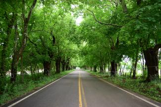
Tree allée, Beaver River Road Historic District, Richmond
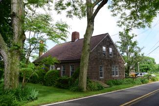
Jamesford Farmhouse (ca. 1800), Beaver River Road Historic District, Richmond
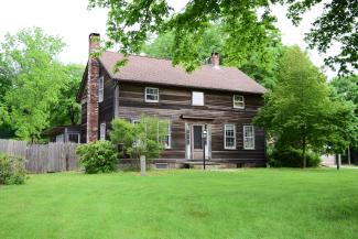
Walnut Hill Farm/Cliffmore House (ca. 1860), Beaver River Road Historic District, Richmond